Teiki Mathieu Baillan surfing a self-made Alaya surfboard in Macaroni, Mentawaï, Indonesia. Photo by C. Naslain, 2009.
Appréciez et contribuez !
| Trouvez les meilleur spots |
|
|
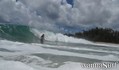
 Anahola Bay
USA, Hawaii, Kauai
Cette carte est interactive ! Utilisez les boutons pour zoomer ou vous déplacer.
|
Datum: WGS84 [ Aide ] |
Latitude: 22° 8.857' N |
Notation (0)
- Ajouter à mes spots de surf
- Commentaires (1)
- sessions (0)
- voyages (0)
- Photos (1)
- Videos (0)
- Partager
- Favoris
-
Vos spots favoris et futures listes de spots
Accès
|
English (Traduisez ce texte en Français): Long, wide calcareous sand beach fronted by a shallow sandbar. The beach park at the north end of the beach is Hawaiian Homes' land that has been leased from the state since 1955. DistanceEn voiture ApprocheAccès direct (< 5 min) Facile à trouver ?Facile à trouver Accès public ?Accès public Accès spécial4x4 |
Caractéristiques du spot de surf
Autre nom The Bay
Qualité du spot
Quality des vaguesNormale
ExperiencePros ou Kamikaze...
FréquenceMarche de temps en temps
Vague
TypeBanc de sable
DirectionDroite et gauche
FondSableux
PuissanceSlab
Longueur normaleNormale (50 à 150m)
Longueur max.Longue (150 à 300 m)
Marées, houle et vent
Direction de la houleNord-est
Direction du ventOuest, Sud-ouest
Taille de la houleCommence à marcher à 1.5m-2m /5ft-6ft et tient jusqu'à 2.5m+ / 8ft+
Condition de maréeMi-marée et marée basse
Mouvement de maréeMarée montante et descendante
Plus de détails
Fréquentation semainePersonne
Fréquentation week-endQuelques surfeurs
Dangers
- Courants/Baïnes
- Localisme
Informations supplémentaires
English (Traduisez ce texte en Français): Surf sites are located in the shorebreak on the sandbar. Unreals is the name of the surf site next to the ruins of the former interisland steamer landing.
Atmosphère
Général
Auteur: Anonyme Contributeurs (2)
 Commentaires
Erreurs, Réactions
Vous pouvez corriger des erreurs ou ajouter de nouvelles informations sur cette page. Si vous avez d'autres commentaires à faire sur cette page, Dite-le nous.
Annonceurs
Wannasurf.com 24/24
Wannasurf.com sur votre portable
![]()
RSS Tous les flux RSS de Wannasurf.com
Newsletter Toutes les nouveautés par courriel
De Anonymous , 17-03-2007
cool place - lots of windswell, good body surfing, lots of reef to watch for. I saw Titus and his daughters surfing there on a small day with offshores, and I saw it get really gnarly on a windswell a few days later. Stay at Auntie Sylvie's if you're in the neighborhood.