Teiki Mathieu Baillan surfing a self-made Alaya surfboard in Macaroni, Mentawaï, Indonesia. Photo by C. Naslain, 2009.
Appréciez et contribuez !
| Trouvez les meilleur spots |
|
|
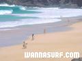
![]() El Risco
El Risco
Canary, Lanzarote
Cette carte est interactive ! Utilisez les boutons pour zoomer ou vous déplacer.
|
Datum: WGS84 [ Aide ] |
Latitude: 29° 12.466' N |
Notation (11)
- Ajouter à mes spots de surf
- Commentaires (11)
- sessions (0)
- voyages (0)
- Photos (1)
- Videos (0)
- Partager
- Favoris
-
Vos spots favoris et futures listes de spots
Accès
|
English (Traduisez ce texte en Français): This is one of the wildest beaches on the island due to its difficult access - by boat from Orzola or by coming down the cliffs at Famara. DistanceEn voiture ApprocheLongue marche (>30 min) Facile à trouver ?Faut chercher un peu Accès public ? Accès spécial4x4 |
Caractéristiques du spot de surf
Qualité du spot
Quality des vaguesNormale
ExperienceTous surfeurs
FréquenceMarche assez souvant
Vague
TypeBeach-break
DirectionDroite et gauche
FondSableux
PuissanceAmusante
Longueur normaleNormale (50 à 150m)
Longueur max.Longue (150 à 300 m)
Marées, houle et vent
Direction de la houle
Direction du vent
Taille de la houleCommence à marcher à et tient jusqu'à
Condition de marée
Mouvement de marée
Plus de détails
Fréquentation semainePersonne
Fréquentation week-endPersonne
Dangers
Informations supplémentaires
English (Traduisez ce texte en Français): park the car 2 km down the hill from mirador del rio close to the village. take enough water for the whole day there is nothing....
Atmosphère
Général
Auteur: frank herrmann Contributeurs (2)
 Commentaires
De anonymous , 06-11-2005
el risco is real - it is not antoher mythos of el risco...the spot exists and sometimes is works very wellall dumbs schouldt check it from mirador del rio!!!and the locals from famara are more handsome than any other local or like my mother..
De Un godo de mierda.... , 03-07-2005
- Lo que sois es unos hijos del a granputa cagones, cada vez que se pone de más de metroymedio tengo que buscar un compinche para no entrar solo.Vete a tomar por culo PELIGROSO...(hay que joderse) Seguro q te encanta el "regeton"y los coches tunin eh? payaso
Erreurs, Réactions
Vous pouvez corriger des erreurs ou ajouter de nouvelles informations sur cette page. Si vous avez d'autres commentaires à faire sur cette page, Dite-le nous.
Annonceurs
Wannasurf.com 24/24
Wannasurf.com sur votre portable
![]()
RSS Tous les flux RSS de Wannasurf.com
Newsletter Toutes les nouveautés par courriel
De Jelle , 31-03-2008
location - Hi, I'm trying to find out where all surfspots are at lanzarote with google earth/maps, but I can't really figure out this spot. I think it is over here (http://maps.google.nl/maps?f=q&hl=nl&geocode=&q=Tenerife,+Spain&ie=UTF8&ll=29.195665,-13.507433&spn=0.029633,0.067635&t=h&z=15), but is this correct? And exactly which part of the coastline that I pointed out, as that part of the coast visible in the link I posted is approx. 3 km long.