Teiki Mathieu Baillan surfing a self-made Alaya surfboard in Macaroni, Mentawaï, Indonesia. Photo by C. Naslain, 2009.
Appréciez et contribuez !
| Trouvez les meilleur spots |
|
|
 Sprat Bay
Virgin Islands
Cette carte est interactive ! Utilisez les boutons pour zoomer ou vous déplacer.
|
Datum: WGS84 [ Aide ] |
Latitude: 18° 19.171' N |
Notation (2)
- Ajouter à mes spots de surf
- Commentaires (4)
- sessions (0)
- voyages (0)
- Photos (4)
- Videos (0)
- Partager
- Favoris
-
Vos spots favoris et futures listes de spots
Accès
|
English (Traduisez ce texte en Français): Take a $3.00 ferry ride from sub base St.Thomas to Water Island(U.S.V.I.'s 4th and newest island)<br />its a 5 min ride, from the dock walk the road about 1mile or try hitch a ride all the way to the east end of the island, you will be at the beach of sprat, paddle about 10 min out to the point, and surf. DistanceA la journée ApprocheLongue marche (>30 min) Facile à trouver ?Faut chercher un peu Accès public ?Accès public Accès spécialA la rame > 20mn ou par bateau |
Caractéristiques du spot de surf
Autre nom Sprat
Qualité du spot
Quality des vaguesClassique régionale
ExperienceSurfeurs expérimentés
FréquenceMarche de temps en temps
Vague
TypePoint-break
DirectionDroite
FondRécif (corail, rochers coupants etc..)
PuissanceCreuse, Rapide, Slab
Longueur normaleNormale (50 à 150m)
Longueur max.Longue (150 à 300 m)
Marées, houle et vent
Direction de la houleSud-ouest, Sud, Sud-est
Direction du ventNord, Nord-ouest, Nord-est
Taille de la houleCommence à marcher à Moins de 1m / 3ft et tient jusqu'à 2m+ / 6ft+
Condition de maréeMi-marée et marée haute
Mouvement de maréeMarée montante
Plus de détails
Fréquentation semainePersonne
Fréquentation week-endQuelques surfeurs
Dangers
- Oursins
- Rochers
- Requins
Informations supplémentaires
Atmosphère
Général
Auteur: Anonyme Contributeurs (2)
 Photos
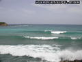
Sprat bay |
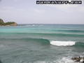
Sprat bay |
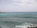
Sprat bay |

Sprat bay |
Commentaires
De beef , 28-02-2014
2014 - Went there on holiday no waves in February. Gate is locked and seems a hassle to get to beach without someone harassing you. It is a private area so public access is stealthy at the best.
De Anonymous , 23-03-2008
or else what? - Or else you're going to challenge me to a spelling contest?
Erreurs, Réactions
Vous pouvez corriger des erreurs ou ajouter de nouvelles informations sur cette page. Si vous avez d'autres commentaires à faire sur cette page, Dite-le nous.
Annonceurs
Wannasurf.com 24/24
Wannasurf.com sur votre portable
![]()
RSS Tous les flux RSS de Wannasurf.com
Newsletter Toutes les nouveautés par courriel