Cette carte est interactive ! Utilisez les boutons pour zoomer ou vous déplacer.
Accès
|
Take a boat to Ollie's and instead of turning into the bay travel further North about 10 minutes or so. You can see on the gps, there's a little thing that looks like a pipline in the water. it's at the end of the pipeline. It's in the middle of the ocean. There's like a little bit of a rock mountain out there. the waves break on both North and south side of the pipeline (or what ever it was) and sort of do a big clap at the end. It was about 5 feet at the biggest. but fun. Better than 5 foot Ollies with 20 kooks. you maybe have to ask extra nice for your skipper to bring you there. It's not much further than Ollies,
English (Traduisez ce texte en Français): Take a boat to Ollie's and instead of turning into the bay travel further North about 10 minutes or so. You can see on the gps, there's a little thing that looks like a pipline in the water. it's at the end of the pipeline. It's in the middle of the ocean. There's like a little bit of a rock mountain out there. the waves break on both North and south side of the pipeline (or what ever it was) and sort of do a big clap at the end. It was about 5 feet at the biggest. but fun. Better than 5 foot Ollies with 20 kooks. you maybe have to ask extra nice for your skipper to bring you there. It's not much further than Ollies,
English (Traduisez ce texte en Français): Take a boat to Ollie's and instead of turning into the bay travel further North about 10 minutes or so. You can see on the gps, there's a little thing that looks like a pipline in the water. it's at the end of the pipeline. It's in the middle of the ocean. There's like a little bit of a rock mountain out there. the waves break on both North and south side of the pipeline (or what ever it was) and sort of do a big clap at the end. It was about 5 feet at the biggest. but fun. Better than 5 foot Ollies with 20 kooks. you maybe have to ask extra nice for your skipper to bring you there. It's not much further than Ollies,
English (Traduisez ce texte en Français): Take a boat to Ollie's and instead of turning into the bay travel further North about 10 minutes or so. You can see on the gps, there's a little thing that looks like a pipline in the water. it's at the end of the pipeline. It's in the middle of the ocean. There's like a little bit of a rock mountain out there. the waves break on both North and south side of the pipeline (or what ever it was) and sort of do a big clap at the end. It was about 5 feet at the biggest. but fun. Better than 5 foot Ollies with 20 kooks. you maybe have to ask extra nice for your skipper to bring you there. It's not much further than Ollies,
DistanceJe ne sais pas
ApprocheJe ne sais pas
Facile à trouver ?Faut chercher un peu
Accès public ?Accès public
Accès spécialPar bateau seulement
|
|
Caractéristiques du spot de surf
Autre nom Gnardog Reef
Qualité du spot
Quality des vaguesNormale
ExperienceSurfeurs expérimentés
FréquenceJe ne sais pas
Vague
TypeRécif de corail
DirectionDroite
FondRécif (corail, rochers coupants etc..)
PuissanceRapide, Amusante, Slab
Longueur normaleNormale (50 à 150m)
Longueur max.Normale (50 à 150m)
Marées, houle et vent
Direction de la houleOuest, Sud-ouest, Sud
Direction du ventNord
Taille de la houleCommence à marcher à 1.0m-1.5m / 3ft-5ft et tient jusqu'à Je ne sais pas
Condition de maréeMi-marée et marée basse
Mouvement de maréeMarée descendente
Plus de détails
Fréquentation semainePersonne
Fréquentation week-endJe ne sais pas
Webcam
Dangers
- Rochers
Informations supplémentaires
Looks like if you went when the swell are coming in consistently at 6+feet. I could be a jem of a wave. It was about 4-5 feet (max) when i was there with three friends. My memory sort of evades me, there's a pipeline that goes all the way out to a big rock or little mountain . It's coral along what ever structure it is that goes out to the island. you can see it on the GPS. there's a right on the south side of the pipeline and a left on the North side of the pipeline. and they clap into one another. But other than the pipeline it's about 20 feet deep. Lots of fish, cool to get some underwater shots.
English (Traduisez ce texte en Français): Looks like if you went when the swell are coming in consistently at 6+feet. I could be a jem of a wave. It was about 4-5 feet (max) when i was there with three friends. My memory sort of evades me, there's a pipeline that goes all the way out to a big rock or little mountain . It's coral along what ever structure it is that goes out to the island. you can see it on the GPS. there's a right on the south side of the pipeline and a left on the North side of the pipeline. and they clap into one another. But other than the pipeline it's about 20 feet deep. Lots of fish, cool to get some underwater shots.
English (Traduisez ce texte en Français): Looks like if you went when the swell are coming in consistently at 6+feet. I could be a jem of a wave. It was about 4-5 feet (max) when i was there with three friends. My memory sort of evades me, there's a pipeline that goes all the way out to a big rock or little mountain . It's coral along what ever structure it is that goes out to the island. you can see it on the GPS. there's a right on the south side of the pipeline and a left on the North side of the pipeline. and they clap into one another. But other than the pipeline it's about 20 feet deep. Lots of fish, cool to get some underwater shots.
English (Traduisez ce texte en Français): Looks like if you went when the swell are coming in consistently at 6+feet. I could be a jem of a wave. It was about 4-5 feet (max) when i was there with three friends. My memory sort of evades me, there's a pipeline that goes all the way out to a big rock or little mountain . It's coral along what ever structure it is that goes out to the island. you can see it on the GPS. there's a right on the south side of the pipeline and a left on the North side of the pipeline. and they clap into one another. But other than the pipeline it's about 20 feet deep. Lots of fish, cool to get some underwater shots.
Atmosphère
cool vibe, i'm sure people have surfed there before me, but you definitely feel like you could be the first one when you get out there. Maybe some big fish too, who knows.
English (Traduisez ce texte en Français): cool vibe, i'm sure people have surfed there before me, but you definitely feel like you could be the first one when you get out there. Maybe some big fish too, who knows.
English (Traduisez ce texte en Français): cool vibe, i'm sure people have surfed there before me, but you definitely feel like you could be the first one when you get out there. Maybe some big fish too, who knows.
English (Traduisez ce texte en Français): cool vibe, i'm sure people have surfed there before me, but you definitely feel like you could be the first one when you get out there. Maybe some big fish too, who knows.
Général
fun time, watch out for the sharp coral if you eat $h1t.
English (Traduisez ce texte en Français): fun time, watch out for the sharp coral if you eat $h1t.
English (Traduisez ce texte en Français): fun time, watch out for the sharp coral if you eat $h1t.
English (Traduisez ce texte en Français): fun time, watch out for the sharp coral if you eat $h1t.
 Commentaires
Tout voir (1)...
Erreurs, Réactions
Vous pouvez corriger des erreurs ou ajouter de nouvelles informations sur cette page. Si vous avez d'autres commentaires à faire sur cette page, Dite-le nous.
Wannasurf.com 24/24
Wannasurf.com sur votre portable

Newsletter Toutes les nouveautés par courriel
 Scardog reef
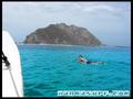
De Kiki , 16-03-2010
- I have been going to Costa Rica for 8 years and every year we a take a trip or two to Ollie's. On March 12, 2010 we headed off to Ollie's and arrived at low tide with waist to chest waves. The boat captain requested to take us to La Isla a/k/a Scardog Reef. When we arrived it was the sketchiest set up I had ever seen from the boat. Once in the water it turned out to be a perfect right hand point break with nice drops and a 100 yard bowl right into a deep channel making for an easy paddle out. It was about head high, maybe bigger on sets. Probably bigger and it would have been epic becuase the wind was light north making it perfectly offshore. At the take off spot the reef is right there. Reminds me of Cane Garden Bay in Tortola